Monday, May 25, 2015

Day 8

Sunday can best be described as a whole lot of action without all that much chasing.

We woke up at our super 8 in Guymon, OK and decided our best option was to hang in the area until something fired in the vicinity.  We went ahead and booked our room for the next night. 

We periodically checked radar and mesoanalysis through the morning into the afternoon.  Several cells fired to our northwest across eastern Colorado, one of which quickly became tornado warned up near Lamar.  We weren't all that thrilled with chasing this because it was a mess on radar and looked to be lining out.  

A cell eventually fired along the far southern edge of this line in the far southeastern corner of Colorado. Since this cell wasn't impeded by anything to its south, we decided to dart north into southwest Kansas to catch a quick glimpse. 

As we got into position, another tiny cell began popping just ahead of it which we could visibly see just to our west.  We decided to pull off and watch as it grew and eventually got absorbed into the line.  

At this same time, a few cells began firing behind us (to our southeast).  It was amazing how quickly these were climbing.  They were clearly organizing on radar so we decided to bail off the line and go check them out.  

As we dropped south and eventually east  towards liberal, velocity scans indicated 2 separate areas of rotation...one of which was quite strong.  This really grabbed our attention and it wasn't long until the stronger area became tornado warned.  

As we passed through Hugoton, we had to make a decision regarding which cell to pursue.  The northern cell lost its tornado warning with both now severe warned.  We could see the bases of each so we decided to keep tracking east keeping an eye on both. 

We got to the point where we were (safely) sandwiched between each cell moving east north east.  We pulled off the road where we could look to our left and see the wall cloud of the northern cell or to our right to see the wall cloud of the southern one.   

At different times, each cell showed signs of becoming the dominant cell making our best positioning move a tough one... a great predicament to have.  The couplet on the southern cell eventually tightened up so we dropped south to just north of liberal to grab a better look.  As we re-positioned, we saw a skinny rope tornado drop for about 10-15 seconds.  Unfortunately, our gopro on the dashboard of the truck didn't quite pick it up.  Jeff Frame (@VORTEXJeff) got a quick picture of it below...the skinny rope down in the center.


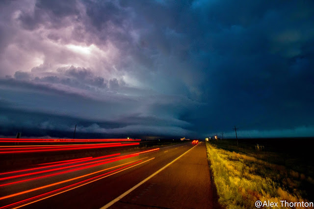
The cell had a ground scraping wall cloud here and an amazing mammatus field... By far the best I've seen.  Unfortunately, the sun was now setting and we weren't thrilled with the idea of chasing a tornadic supercell into the night.  We pulled over and watched lightning light up our cell as it dashed away.  It was soon after that reports and pictures of a large wedge tornado with it started coming in.  It certainly would have been nice to have a few more hours of daylight but that's just how things are sometimes. 

We only had a 45 minute drive back to our hotel in Guymon making this by far our shortest mileage trip of the chase.  That on top of everything we saw, we certainly consider it a success.  

Below are some pictures taken by Alex over the course of the evening:


Thursday, May 21, 2015

Day Four

It's Alex, checking in again! 

Day four was not as active as day three (find that tornadic supercell recap here) but it was nowhere near disappointing. We set ourselves up well the night before by settling down in Fort Stockton and did not have to rush to catch anything. The storms came to us! We hung around Fort Stockton till around 12:30pm watching storms around us attempting to break the cap(hinders storm formation). Then finally, our first cell formed just north of the town we were in. Because we were so close, we were able to get into position quickly. We watched this cell for about 30 minutes. I was even able to get a stream running from Periscope since we actually had cell service. The storm had periods of good inflow but this was soon cut off by other cells that formed nearby. When the storm was healthy, I was able to snap a few photos of the structure that we were able to see.


After the death of our main storm, we decided to go check out another one that was forming just east of Fort Stockton. Once we got to the back edge of the storm, we realized that not much was going to come of this cell. Since we knew this would be the last storm for the day, we decided to drive further into it and see if we could catch a glimpse of the hail while parked. Radar had indicated quarter sized hail, which we knew the StormCruzzer could handle.( *note* do not do this with your car, it will get messed up) We were personally interested to see if we could verify the hail size and report it to the local NWS station. We were able to retrieve a few pieces of hail as the storm passed over us. Most of the hail was indeed .25 inches in diameter. However, We did retrieve some pieces that were about an inch in diameter.


Overall I would call this a successful chase day! We will likely be leaving Fort Stockton today and heading north to set up for the next system!

Be sure to follow us on facebook and twitter!

https://www.facebook.com/stormcruzzer

https://twitter.com/StormCruzzer


Wednesday, May 20, 2015

Day Three (second day chasing)

Alex Thornton checking in....
Day two consisted of a ton of excitement and a good bit of disappointment as well. When we woke up in Odessa yesterday, we were already in a great position. The conditions were great for the formation of severe thunderstorms and possible tornado activity. We waited in Odessa until around noon before making our first move. The HRRR and NAM had both hinted at a long living cell that would set up south of Highway 10 around McCamey, Texas. Therefore, when we started seeing cells popping up in that general area, we blasted south to try and catch it. In the process of doing this, I lost my hat out the window while taking some pictures(R.I.P). Soon after setting up in a position where we had a good visual, we spotted our first Tornado.


 Because we were there from the very beginning, we were able to give early warning to the surrounding towns and their law enforcement. Soon after making our report, the cell was Severe Warned and also Tornado warned. The tornado lasted somewhere around 5-8 minutes and we watched it from start to finish!


We repositioned ourselves further south(storm had southward motion) and observed the cell as it matured even further. The structure that we observed was amazing. I was able to pick out every textbook structure that supercells usually have. This cell continued to be Tornado warned as we watched for the next few hours. 


In the process of observing we came in close contact with many anvil lightning strikes which inspired us to move further south. One strike(which we caught on camera) was easily within 20 yards of the truck as we were all sitting inside. *Sidenote* seconds before the lightning struck we all heard a static noise and had the full on experience of the hair on our arms sticking up. 

After moving south to get further from the lightning threat, we were able to find another good vantage point and pulled off the road. At this point, the cell was still tornado warned and more chasers began to show up. This is also the point where we began to be out of cell service and would be for most of the day. 
The radar images that we did get minutes before indicated an area of strong rotation and hook echo. The only problem was, rain was hindering us from seeing much into the inflow area of the storm(best viability spot). We could see a pronounced base and brief periods of a hanging wall cloud. 
Before too long, some of the rain cleared out as it neared our position and we were able to make out our second tornado of the day. We were able to watch it for a few minutes before rain made it too hard to see once again. We also think that it soon dissipated after this. 

As the cell got closer, the structure became amazing!


As the storm continued to move south east, we noticed that we needed to move further south in order to not get caught up in what was more than likely 1(+) inch hail. In the process of doing this, we came in extremely close contact with the business end of the storm. 


The structure found in this part of the storm was unreal. We were able to safely get south of the storm and eventually get further east. We also found ourselves getting low on gas and had to make some difficult decisions. We ended up jumping off the storm and heading to Sanderson, Texas to fill up on gas. From here we headed to Fort Stockton to get a hotel room. 

Tuesday, May 19, 2015

Chase Day 2

We left our hotel room in Tulsa, OK Monday morning at 10am central time.  Although it appeared a few severe storms would fire in western Texas by afternoon, we still had quite stretch to get out there.  We decided this would be another “travel day” and any on-the-go intercepts would be a nice bonus.

As we crossed the Oklahoma/Texas border, we noticed some higher topped cumulus starting to go up in far southwestern Texas which early morning runs of the HRRR and High-Res NAM had hinted at.  It became clear that we’d have a shot to chase these for a few hours before we lost daylight.

Shortly before 6, the prominent cell became tornado warned near Pecos.  We were still a few hours away in Big Spring but continued our race southwest.  When we got to Odessa, we dropped south to Crane before edging west and then southwest towards Imperial.  It was from here that we had a few good looks at the leading edge of the storm.
 
 
Mammatus

The road network certainly wasn’t the greatest and we were also forced to detour around a construction zone that had stopped traffic.  The storm really slowed due to lack of much midlevel flow allowing us to navigate right around the anvil.  By this time, a few additional thunderstorms began to pop to our south…eventually merging with our cell and forming a bowing segment.  It was here we decided to call it quits and head to find dinner and our hotel for the night in Odessa, Texas.  Fortunately, it looks like we are well positioned for Tuesday meaning we’ll have our first true chase day without much traveling to our target.
After knocking out another 648 miles, we’re pretty pleased with how the day turned out.  It would have been nice to have a bit more time to look into the inflow notch, but also feels good having our first plains super cell (tornado warned at that) under the belt. 

Monday, May 18, 2015

StormCruzzer Chase Day 1

We departed Blacksburg Sunday at 11am with a goal of making it to western Missouri. We ended up pushing all the way to Tulsa, Oklahoma...totaling 1102 miles for the day.  Part of our decision to take the northern route revolved around the opinion that it's a more scenic route (most notably crossing the Mississippi River in St Louis.  Below are some pictures from our day. 
St. Louis Arch


Since we didn't pull into our hotel in Tulsa until 4am local time, we made a decision to grab a few more hours of sleep this morning and not depart until 10.  We would have needed to leave around 7am if we wanted to get to western Texas in time for storm initiation.  Since our Tuesday target is western Texas anyways, any storm we happen to catch this evening will just be an added bonus.  Our first full throttle chase day will be tomorrow.